oooo
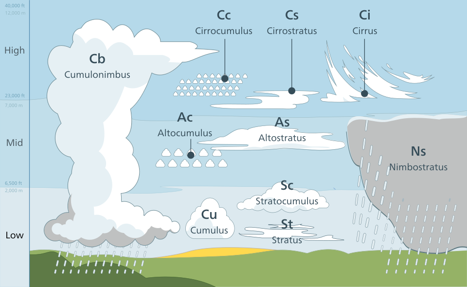
(Above infographic from wikimedia.org)
oooo
Low Clouds
(below 2,000 feet)
Mid-Level Clouds
(6,500 feet – 23,000 feet)

High Clouds
(23,000 feet – 40,000 feet)
oooo
oooo
Key Cloud Classifications (Based on Height and Form)
- Vertical Development
– Clouds with great height.
– Cumulonimbus (Cb) are massive tower clouds that create thunderstorms, while Nimbostratus (Ns) produce steady rain.
o - Low Clouds
– below 2,000m/ below 1 mile / below 2km.
– Mostly water droplets.
– Includes thick, flat Stratus (St) ~ often creating fog), fluffy Cumulus (Cu), and layered Stratocumulus (Sc).
o - Mid-Level Clouds
– between 2,000m – 6,000m / between 1.2 – 3½ miles / between 2 -6km.
– Composed of water droplets/ice.
– Often prefixed with “alto-“, such as Altocumulus (Ac) and Altostratus (As).
o - High Clouds
– above 6,000m / above 3½+ miles / above 6km.
– Composed mostly of ice crystals.
– Includes patchy Cirrocumulus (Cc), sheet-like Cirrostratus (Cs), wispy Cirrus (Ci).
o
o
o
oooo
- Low Clouds
– below 2,000m/ below 1 mile / below 2km.
– Mostly water droplets.
– three different types of low clouds level: Stratus / Stratocumulus / Nimbostratus (see below).
oooo
- Flat, uniform gray layer.
- Can bring light drizzle or mist.
- Makes the day look dull and overcast.
- Often covers the whole sky like a blanket.
- Common in stable weather conditions.
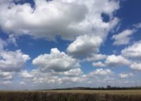
- Low, lumpy clouds in patches or rolls.
- Usually white or gray with darker areas.
- Rarely produces heavy rain.
- Often lasts for hours.
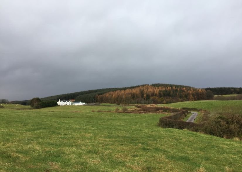
- Thick, dark, and widespread.
- Sun is completely blocked out.
- Associated with continuous rain or snow.
oooo
oooo
- Mid-level clouds
– between 2,000m – 6,000m / between 1.2 – 3½ miles / between 2 -6km.
– Composed of water droplets/ice.
– Divided into two main types: Altocumulus and Altostratus (see below).
oooo
- Gray or bluish sheet covering much or all of the sky.
- Sun may appear as a dim, blurry spot.
- Often forms ahead of widespread rain or storms
- White or gray patches, often in rounded clumps or waves.
- Sometimes described as a “mackerel sky”.
- Can indicate unstable air and possible thunderstorms later.

oooo
oooo
- High Clouds
– above 6,000m / above 3½+ miles / above 6km.
– Composed mostly of ice crystals.
– Divided into 3 main types: Cirrocumulus (Cc), sheet-like Cirrostratus (Cs), and wispy Cirrus (Ci) (see below).
oooo
- Thin, wispy, feather-like clouds.
- Usually white and delicate.
- Often indicate fair weather, but can signal a change coming
- Thin, milky veil covering the sky.
- Can create a halo around the Sun or Moon.
- Often appears before rain or snow.

- Small, white patches or ripple.
- Look like fish scales (“mackerel sky”).
- Usually seen in fair but cold weather.
oooo